Map Your Watershed and Bioregion in 15 Minutes (From Scratch!)
by Sam Butler and Brandon Letsinger
“Food coming from local food sheds, roughly mapping over local watersheds … forming a more ecological basis, for a bioregional future.” (Max Ajl, “A People’s Green New Deal”)
Recieve future content like this
This document will guide you in finding your own local watershed and bioregion (and even ecoregion, if you like) — so you can start planning your bioregional future. At the end, you’ll also be able to share your work with others, so we can connect and collaborate on these efforts as a community.
If you want more details and discussion, you can try this 1-hour mapping workshop, which can be useful for teaching, classroom contexts, social gatherings, and events around bioregional mapping.
(You can also access this page on Google Docs to make comments, suggestions, or follow along there.)
What is a bioregion?
A bioregion is a land and water territory whose limits are naturally defined by topographic features (such as mountain ranges and rivers) and biological features (such as plants, animals, humans and entire ecosystems).
Bioregions are the natural countries of the planet, and the largest framework in which shared experience based on place makes sense. Bioregions transcend arbitrary political boundaries, and are interconnected with one another.
Bioregional mapping can also serve as a launching point for organizing, planning, sustainability projects, and more!
Did you know?
At the 1992 United Nations Rio Conference on the Environment, bioregional mapping was identified as a best practice for locally-based sustainability planning.
Now, we’ll start mapping our own bioergion. You can work as a team, individually, or in small groups. At the end of the exercise, you’ll have a chance to share your work with others making these maps too!
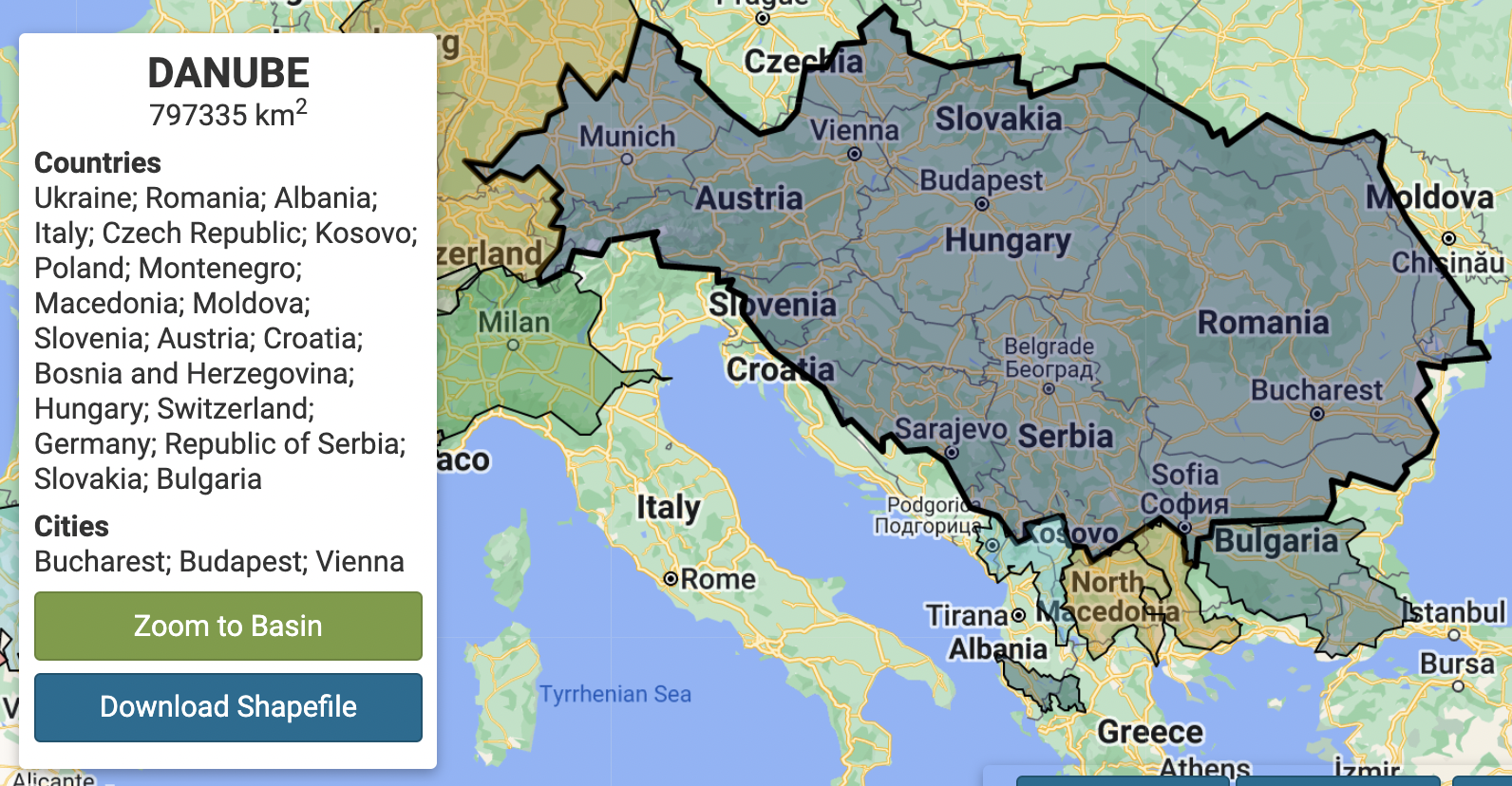
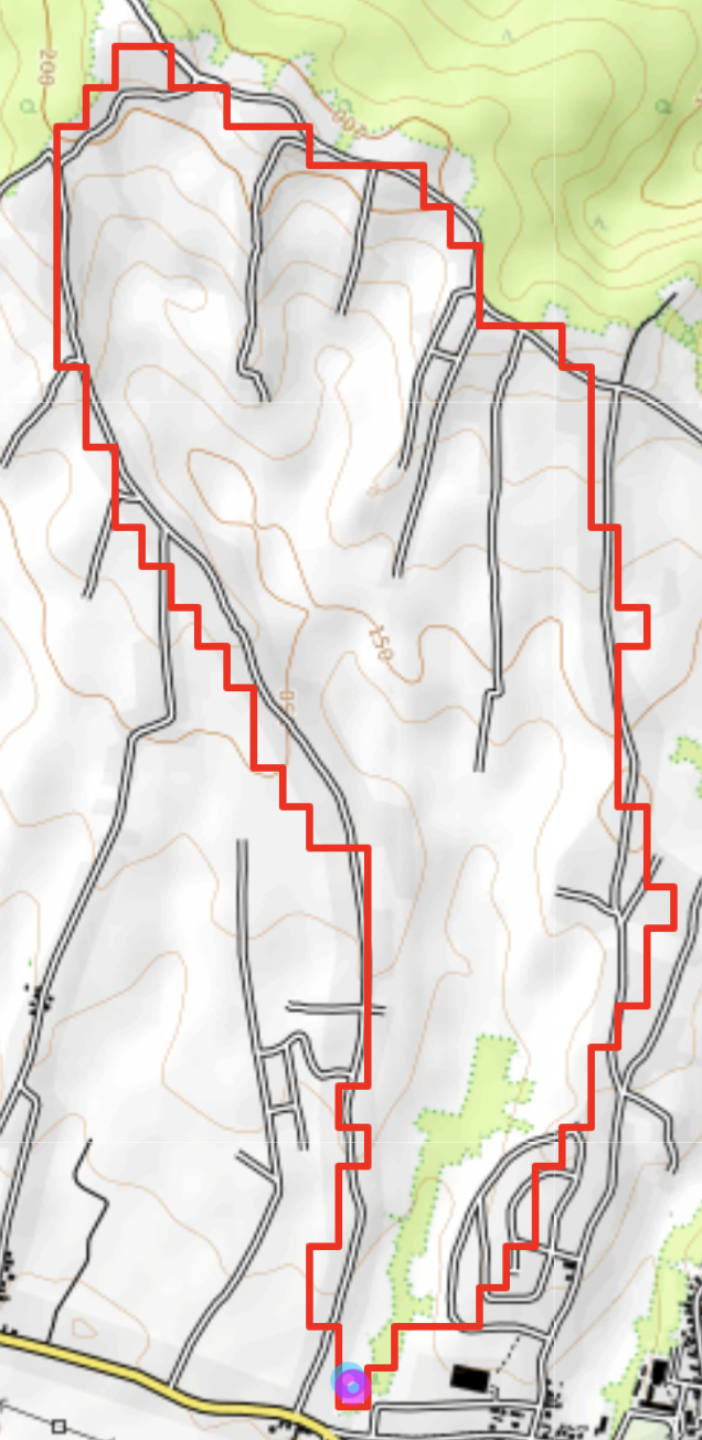
First, find yourself. Where is your local watershed (drainage basin) ?🔧 https://mghydro.com/watersheds/
Using the tool above, it will look something like this (and maybe, much larger!)
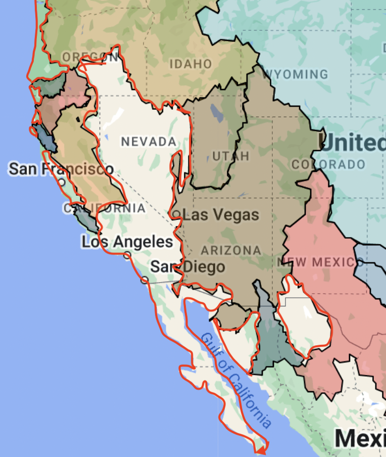
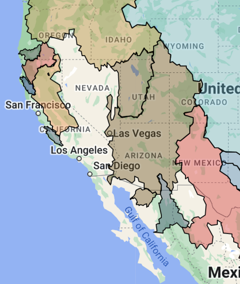
Now, find the largest watershed or drainage basin around you🔧 http://riverbasins.wateractionhub.org/
Did it work? Are you looking at a “natural country” of sorts — a place that may span national boundaries, with the common shared experience of a drainage basin and major river?
If so, you just found the rough borders of your bioregion!
❗What if you live outside a major drainage basin — like a coastal land, or a drier inland “endorheic” drainage basins (basins which flow into themselves, rather than an ocean or sea)?
In these cases, we’ll have to consult some other natural features and map layers, to find the “hard edges” of our bioregion and make some decisions about the bounds.
If you already found your bioregion, you can skip ahead to Testing Your Bioregion, or read on for more details about bioregional mapping.
Finding your bioregion outside a major drainage basin
1. Find the river basins around your location
🔧 http://riverbasins.wateractionhub.org/
2. Now, explore more hard natural boundaries around your area — mountain ranges, elevation levels, soil types, climate and weather patterns — to get a clearer picture of the edges around your bioregion.
🔧 More details on "hard edges"
3. Based on the hard edges you’ve found, mark the initial boundaries of your bioregion — and voi la! You should be looking at a potential map of your bioregion!And now you’re ready to test it.
Testing your bioregion
How do you know if the bioregion you’ve mapped, is, well, a bioregion?
After finding the hard boundaries of our region, we can also check “soft” internal boundaries like ecosystems and and human cultural boundaries, to see if it passes tests like the following.
While our bioregional boundaries will not shrink at this point - they may grow!
Self Sufficiency Test:Is this bioregional area large enough to be practically self-sufficient? (While no one area may ever be truly self-sufficient, a majority of cultural and geographic connection should take place within a bioregion.)
Where does the food and power come from?
What resources are generated in the region?
Who are people talking to, working with, what are the economic hubs, and connection points?
Where does the water come from and go?
Are there natural disasters that affect areas broader than what you mapped?
How do the areas in the region work together? Do you feel there is a sense of shared identity?
Water Test: Are there any other bodies of water that feed into this area? Or water in this area that feeds into other regions? Look for layers of interconnection and interdependence.
❗As you answer the questions above, you may find reason to expand the bounds of your bioregion to encompass more neighboring areas. If so, do it! (There’s no right answer — and anybody can make their own map, based on their own responses to these questions!)
If your area performed well in these tests, you are looking at your bioregion!
Follow Up and Next Steps
As a wrap-up, try the following prompts.
What are the boundaries of your bioregion?
You can draw them on paper, on a digital map, or describe them however suits you. 🔧https://geojson.io/
Do you have a possible name for your bioregion / ecoregion? (Remember — there are no right or wrong answers!)
Now that you have a bioregion, what features and layers would you add to the map — things that are important or special to you, or things that you depend on?
Do you feel this map might be useful to groups, organizers or people living in it? How or why? (If not, how could it be different?)
What other hard edges, soft edges, or cultural layers in your bioregion are you curious about, but didn’t yet have time to explore?
Congratulations! You now have a bioregion — from the largest drainage basin or coastline, all the way down to your watershed — and maybe even a name for it!
Share your Bioregion!
Share the outcomes of your bioregional mapping, so other people can see where you’re at and learn from your effort, and you can connect with others doing the same!
1. Add details and an image/screenshot of your bioregion here:
Bioregions, Ecoregions, Watersheds of the World
2. Add your bioregion to this collaborative map — either by uploading coordinates (e.g. geoJSON, shapefile), or drawing a general picture of your region on the map:
http://umap.openstreetmap.fr/en/map/anonymous-edit/860039:ujKIMAZjadv_8vUqsgAEu7JdIz0
3. If you’d like to get in touch with the creators of this resource, feel free to write to Brandon (cascadia@deptofbioregion.org) or Sam (gmail@sambutler.us)!
Mapping within — Finding your ecoregion
If a bioregion is a house, ecoregions are like rooms in the house — in administrative language, a scale between counties and countries.
And whether your bioregion feels a little too large to identify with, or you’d just like to explore other scales of commonality and shared experience around you, you can look to local ecoregions!Ecoregions of different scales can be found in every bioregion. They are more subjective and opinionated, based on soft layers and human cultural bounds (see more)
Finding your ecoregion (in Turtle Island)
https://bplant.org/regions.phpYou can use this tool to explore different scales of ecoregions in North America, going all the way down to your local ecoregion! (If you have trouble, you can search directly here: https://bplant.org/ecoregion_locator.php)
Finding Your ecoregion (outside of Turtle Island)
Open Wikipedia’s global drainage basin list (https://en.wikipedia.org/wiki/List_of_drainage_basins_by_area)
Find the largest drainage basin around you.
Now, click the Drains to ↕️ column header, to sort the table alphabetically by where different basins drain out from.
Find the basin/s that drain out to your largest drainage basin/primary river from Step 2.


Research the basins that show up in the table to find ones near you — these are sub-basins of your largest drainage basin. (You may immediately recognize the name of a river or water body in your region.)
Explore the bounds of the sub-basin that you found in Step 5.
You should now be looking at a natural area that feels a little closer to home, which may be you ecoregion!And just as you refined or expanded the hard edges of your bioregion, you can do the same — based on hard edges, soft edges, or human cultural edges — for your ecoregion.You may find that your ecoregion may make more sense, in terms of commonality and shared experiences!For example, here is a bioregion:
Within the Danube River Basin, we can also find ecoregions — like the Sava River Basin:
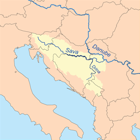
https://en.wikipedia.org/wiki/Sava
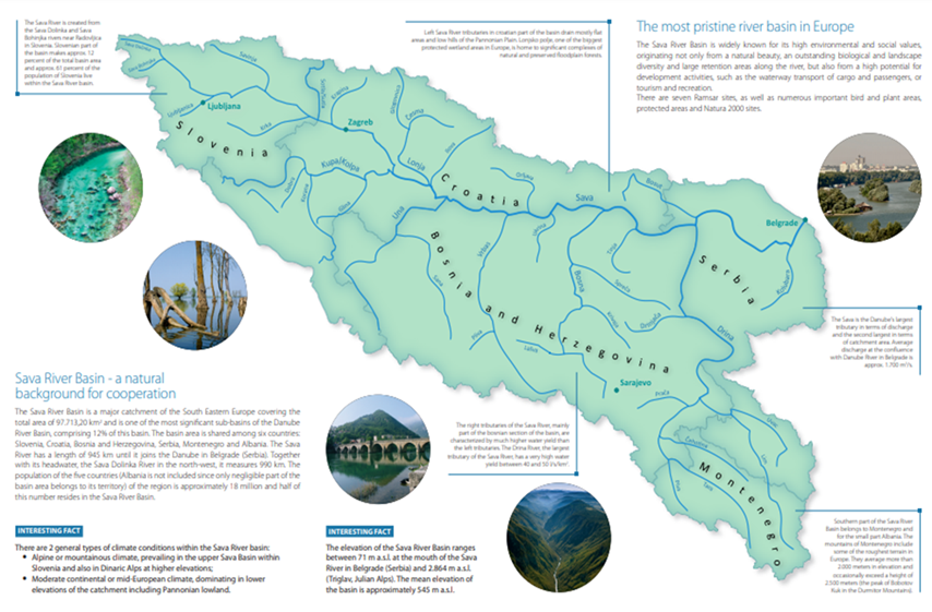
https://www.savacommission.org/about-us/sava-river-basin/7
You would find the Sava River Basin features many of the criteria discussed above. It features common ecosystems, languages, histories, and cultures.
And looking at more soft natural layers and cultural layers, we can find even more ecoregions within it — for example, ecoregions based on common pronunciations of the word “bread”!
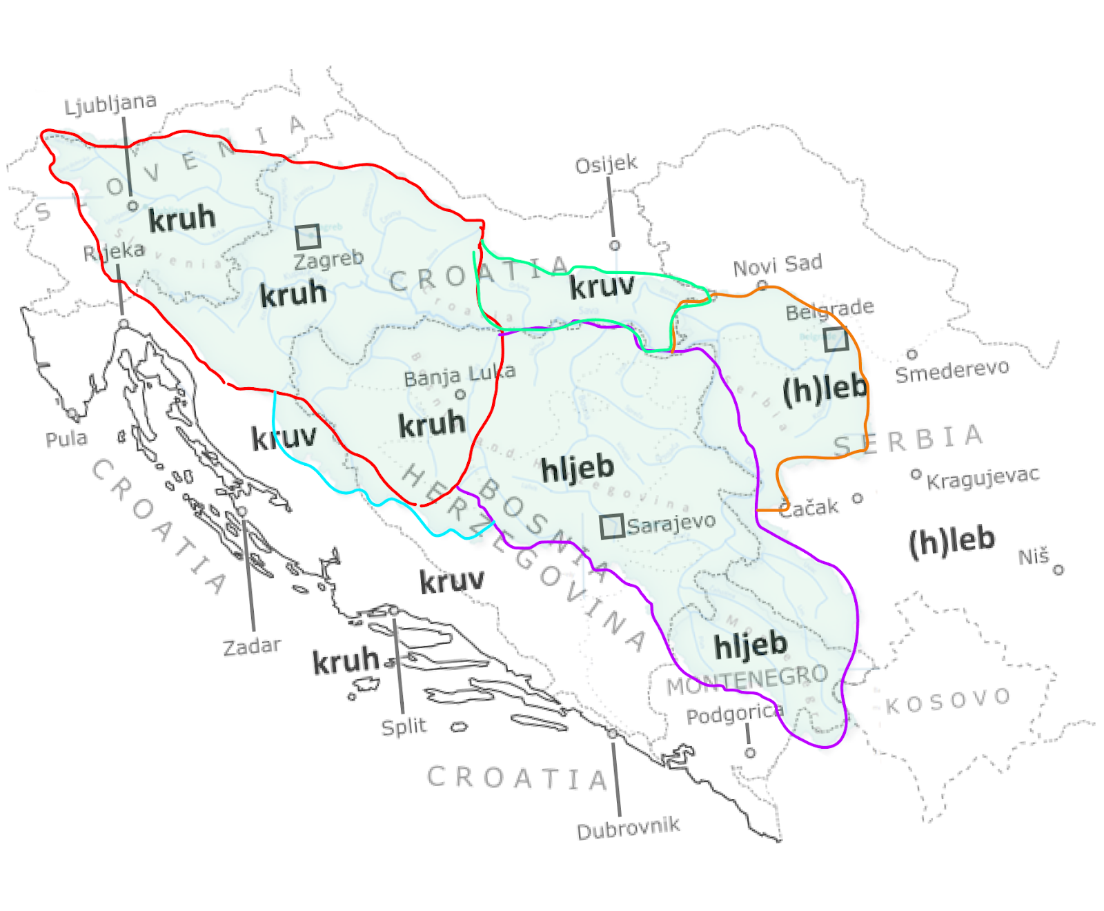
Map of the word “bread” across ex-Yugoslavia from easy-croatian.com, with overlay of Sava River Basin from https://www.savacommission.org/about-us/sava-river-basin/7.
Ecoregions are opinionated, subjective, and ultimately, based on what is important and worth mapping to us. So explore layers and features, create your own, and share the results! (https://rebrand.ly/your-bioregion-here)